Utilizing modern technology to revolutionize your hunting strategy and success
As avid hunters, we are always on the lookout for new ways to improve our skills, especially when it comes to public-land deer hunting. In recent years, technological advancements have given rise to a plethora of hunting apps that offer invaluable assistance, making traditional printed maps almost obsolete. In this article, we explore how hunting apps can elevate your public-land deer hunting experience, providing useful insights and information to help you become a more effective hunter.
Discovering Public Lands and Navigating Boundaries
Modern hunting apps come equipped with layers that highlight public land properties, making it easier for hunters to identify new hunting grounds or better understand familiar territories. With the ability to track your movements and pinpoint property boundaries, these apps ensure that you remain within legal hunting zones at all times.
Analyze Properties and Identify Key Terrain Features
Unlike printed maps, hunting apps allow you to zoom in and out to analyze properties on multiple levels. This capability is crucial for identifying key terrain features such as crops, CRP, coniferous stands, islands of cover, oxbows, timber harvests, and more. With this detailed information, you can make informed decisions about where to set up your hunting spots.
Understand Topography and Deer Behavior
Deer are significantly influenced by topography, and understanding how their behavior is affected by various land features is essential for a successful hunt. Use hunting apps to study essential topographic features, including benches, bottoms, ditches, drainages, draws, flats, hills, hollows, ridges, leeward ridges, marsh interiors, points, pinch points, swamp interiors, waterways, and more.
Assess Habitat Maturity and Locate Essential Resources
Whitetails prefer early successional habitats, which offer the bedding cover, security, and browse they need to thrive. Hunting apps can help you assess habitat maturity and identify these prime areas by analyzing differences in overhead canopy color. Additionally, these apps can assist in locating vital resources such as bedding areas, food sources, and watering spots.
Streamline Scouting and Identify Potential Honey Holes
Hunting apps can significantly improve the scouting process by helping you identify areas to avoid, such as homogenous terrain or large tracts of mature timber. By focusing your efforts on more promising locations, you can save time and increase your chances of success. Moreover, these apps can help you pinpoint potential honey holes, allowing you to mark and navigate between them more efficiently.
Access Real-Time Landscape Change Updates and Offline Map Versions
With certain apps like HuntStand, you can receive monthly updates on aerial imagery, providing valuable information on property changes such as crop rotations, timber harvests, and land alterations. Additionally, most hunting apps offer the option to save offline map versions, ensuring that you can access crucial information even in areas with limited or no cellular service.
Record Scouting Finds and Keep Track of your Treestand Locations
Hunting apps make it easy to document your discoveries, such as beds, rubs, scrapes, food sources, watering areas, and more. You can also mark the locations of deployed gear, such as treestands, blinds, and trail cameras, ensuring that you never lose track of your equipment.
Enhance Navigation and Monitor Hunting Companions
One of the most significant benefits of hunting apps is their ability to assist with navigation, helping you find your way to and from your hunting spots with ease. Many apps offer GPS tracking, ensuring that you can easily retrace your steps, even in the most challenging terrain. Additionally, some hunting apps have features that allow you to monitor the locations of your hunting companions, promoting safety and communication in the field.
Stay Informed About Weather, Wind, and Moon Phases
Weather conditions, wind direction, and moon phases can have a significant impact on deer behavior. Many hunting apps provide real-time weather updates, enabling you to plan your hunting strategy accordingly. By knowing the wind direction and speed, you can set up your hunting spots in a way that maximizes your chances of remaining undetected by deer. Similarly, understanding the moon phases can help you determine the best times to hunt, as deer movement often increases during specific phases.
Customize Your Mapping and Data Visualization Experience
One of the most appealing aspects of hunting apps is their ability to offer a customizable experience tailored to your preferences. You can choose which layers and data to display, ensuring that the information you find most useful is always at your fingertips. This level of personalization allows you to create a truly efficient and effective hunting experience.
The integration of advanced hunting apps into your public-land deer hunting strategy can significantly enhance your experience and success. From identifying public lands and key terrain features to analyzing habitat maturity and locating essential resources, these apps offer invaluable insights and assistance. By streamlining the scouting process, offering real-time updates, and providing essential navigation tools, hunting apps have revolutionized the way we approach public-land deer hunting. Embrace the power of technology and elevate your hunting game to new heights. In no particular order here are some of the best hunting apps of 2023.
1. onX Hunt
Key Features:
- GPS tracker and waypoints
- Accurate land ownership maps and property boarders
- Works offline
- Exclusive services for Elite Members
onX Hunt is a popular hunting app designed to help hunters increase their odds of success by providing accurate land ownership maps, property lines, and GPS tracking. It offers maps for all 50 states and works offline, making it ideal for use in remote areas. With the Elite membership, users gain access to exclusive services and benefits from leading hunting brands.
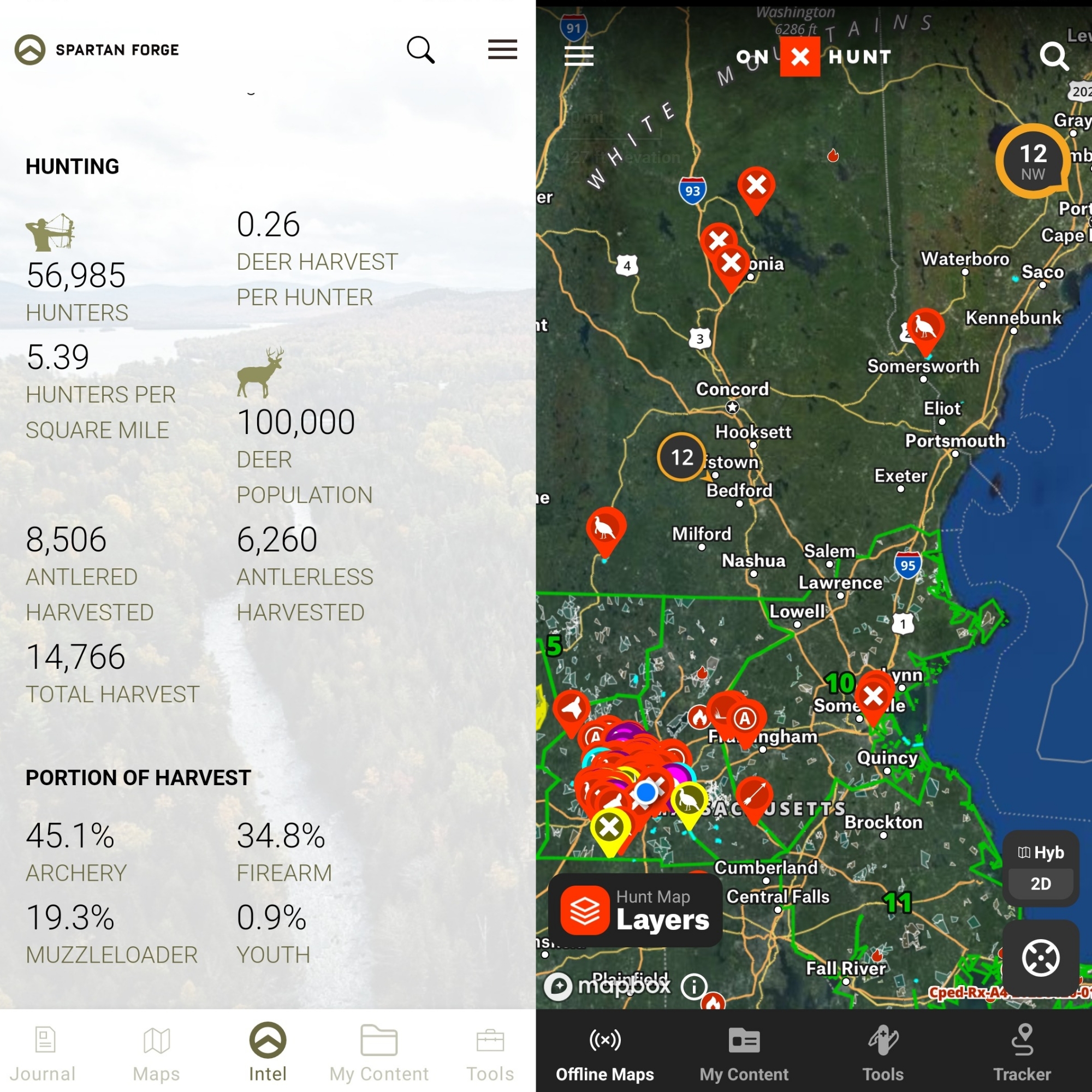
2. Spartan Forge
Key Features:
- Artificial intelligence for deer movement prediction
- UAV imagery for enhanced mapping features
- Offline maps and historical weather data
- Blue Force Tracker tool for real-time data sharing
Spartan Forge uses artificial intelligence to predict deer movement and provide bolstered mapping options due to the use of unmanned aerial vehicle (UAV) imagery. The app is available on iOS and Android devices and offers multiple map types with the highest level of detail. Spartan Forge combines GPS studies, deer biologist fetus studies, car accident reports, and other data to determine the best time for peak breeding, along with moon, wind, and weather information.
3. HuntWise
Key Features:
- Weather forecasting tool
- Mapping tool with over 450 hunting maps and satellite imagery
- HuntCast feature for game prediction
- Real-time hunt area and pin sharing
HuntWise is a comprehensive hunting app available on web, iOS, and Android devices that provides hunters with the ultimate hunting advantage. The app has several key features, including weather forecasting, mapping tools, and HuntCast, a game prediction feature based on moon phases, temperature, and weather. HuntWise also allows hunters to share their hunt areas, pins, notes, and images with others in real-time.
4. HuntStand
Key Features:
- Navigation, mapping, and land management tools
- Weather, solunar, and social features
- Sync hunting area maps across devices
- HuntStand Pro upgrade with advanced features
HuntStand is a powerful hunting and land management app that offers a wide range of features. The app provides navigation, mapping, land management, reporting, weather, solunar, social, and collaboration tools. HuntStand Pro, an upgrade option, includes advanced features like measurement tools and treestand management for an even more valuable experience.
5. Google Earth
Key Features:
- Satellite imagery and topography
- Historical imagery for scouting
- Measure areas and save high-resolution images
- Free to use on computer and mobile devices
Google Earth is a powerful tool for hunters, providing satellite imagery, topography, and other geographic data to represent the Earth as a three-dimensional globe. Hunters can use Google Earth to scout for potential deer cover and study maps to gain insights on the best hunting locations.
As you can see some of the best hunting apps of 2023 for saddle hunting offer a wide array of features and benefits to help hunters improve their experience in the field. From GPS tracking and accurate land ownership maps to artificial intelligence for deer movement prediction and advanced weather forecasting tools, these apps aim to provide the ultimate advantage for modern hunters. Before heading out on your next hunting adventure, consider downloading and familiarizing yourself with one or more of these top-rated apps to maximize your chances of success. Happy hunting!